RENUKA RAI | Thimphu
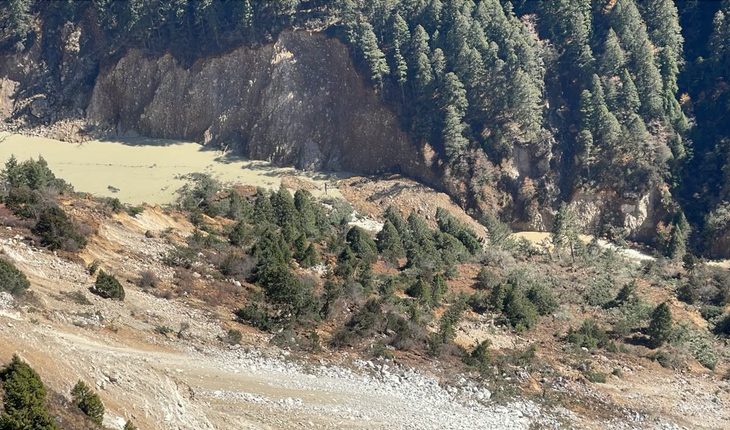
A second lake breach in the upper Sintaphu Chhu area has washed away temporary bridges at Tongchudra and Taktsimakhang in Gasa, raising fresh concerns about continuing hazards following the October 29 Glacial Lake Outburst Flood (GLOF) from Sintaphu Tsho.
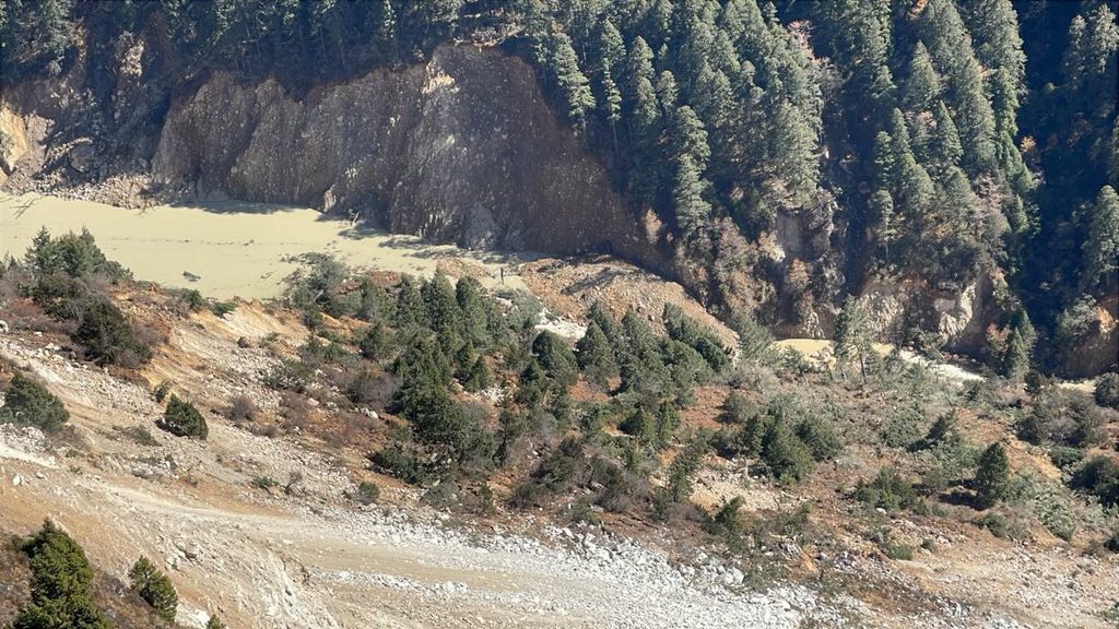
The newly formed artificial lake, created by debris from a landslide about one kilometre upstream of Taktsimakhang, breached on November 6, releasing accumulated water downstream. The incident followed further slope failures in the area, where landslide activity remains high.
According to the Gasa Dzongkhag Administration, the water flow increased following the breach but subsequently returned to normal. The administration has advised the public not to travel towards Laya until further notice following the loss of the temporary bridges.
No casualties have been reported from the latest incident. The Director General of the National Centre for Hydrology and Meteorology (NCHM) clarified that the newly formed lake is separate from the artificial lake associated with Lungu Chhu, also known as Gangchen Tag Chhu, above Taktsimakhang.
A joint technical team from NCHM and the Department of Geology and Mines (DGM) continued its field assessment of the landslide-dammed section of Sintaphu Chhu on November 6.
During the assessment, the team observed additional slope failures at around 8:20 am. However, it reported no substantial river outflow following the breach of the landslide dam.
Officials from NCHM, DGM, the Department of Local Governance and Disaster Management and the Royal Bhutan Army are monitoring the area and assessing possible risks to downstream communities.
The latest incident comes as authorities continue to investigate the October 29 GLOF, which released approximately 4.89 million cubic metres of water from the two connected glacial lakes in Laya.
The flood sent a massive surge of water and debris through the Mo Chhu basin, damaging sections of the Punakha-Gasa highway and Gasa-Laya Road, washing away bridges and destroying facilities at Gasa Tshachu.
The Punatsangchhu-II Hydropower Project also suspended power generation for 71 hours, resulting in an estimated revenue loss of Nu 194 million.
A satellite assessment by Noida-based geospatial intelligence company Suhora Technologies found that the surface area of Sintaphu Tsho’s lower lake had decreased by approximately 73 percent following the outburst.
The lake contracted from 24.13 hectares on October 28 to 6.54 hectares after the disaster.
The assessment, based on high-resolution satellite imagery acquired on October 30, also found that the adjoining supraglacial lake had decreased by 24.4 percent, from approximately 16.50 hectares to 12.47 hectares.
Suhora’s analysis of satellite imagery from 2016 to 2026 showed that the lower lake had remained relatively stable over the decade, increasing from 23.33 hectares to 24.13 hectares before the outburst.
The adjoining supraglacial lake, however, followed a different pattern. Its area expanded from 5.74 hectares in 2016 to approximately 16.50 hectares in 2026, indicating substantial growth before the disaster. Despite shrinking after the GLOF, it remains considerably larger than its 2016 extent.
Separate preliminary findings presented by NCHM on November 3 showed that the lower lake lost approximately 81.53 percent of its water volume, with its water level falling by around 28 metres.
The upper lake experienced a smaller reduction, with its surface area decreasing by approximately 9.55 percent and its water volume by 5.39 percent. Its water level dropped by about 0.4 metres.
The two lakes released an estimated 4.89 million cubic metres of water during the outburst but still hold approximately 3.19 million cubic metres, according to preliminary estimates. Of the remaining volume, around 2.1 million cubic metres are in the upper lake and one million cubic metres in the lower lake.
Preliminary analysis suggests that the upper lake breached first, sending additional water into the lower lake and overwhelming its moraine barrier. However, the exact mechanism that triggered the initial breach remains unknown.
The NCHM Director General said a helicopter was deployed to the site on November 5 to investigate the possible cause. The findings are awaited.
Satellite observations also indicate that the upper lake may be refilling, adding to concerns about the remaining water in the basin.
Scientists will need further ground assessments to establish the condition of the lakes, their barriers and the surrounding terrain.
The GLOF has also exposed gaps in Bhutan’s glacial lake monitoring infrastructure. Unlike several lakes in Lunana, which have sensors and early-warning systems, Sintaphu did not have real-time water-level sensors to track changes in lake conditions before the outburst.
The NCHM Director General said the Taktsimakhang monitoring station was completely washed away, while the Tashithang station was damaged beyond repair.
Mobile connectivity nevertheless played an important role in sharing information during the disaster. Herders in the area were able to send updates through mobile networks and communication groups, helping authorities receive information about the developing situation.
According to Karma, a cryosphere specialist with NCHM, the Sintaphu lakes were last assessed in 2023, with the next assessment scheduled for the 2027 financial year. The GLOF occurred before the planned assessment could take place.
He said Bhutan has 17 potentially dangerous glacial lakes across its northern regions, making it difficult to conduct annual field assessments of every lake. Other river basins, including Chamkhar and Mangde Chhu, also contain potentially dangerous lakes.
NCHM is looking at strengthening monitoring through drones and night-vision cameras, alongside existing measures such as satellite imagery, CCTV cameras, water-level sensors and early-warning systems.
Night-time monitoring is particularly important because many GLOF events occur during the night, when changes in lake conditions may be difficult to observe.
While extensive monitoring and early-warning systems have been established for the glacial lakes in Lunana, the Sintaphu disaster has highlighted the need to strengthen similar arrangements across other vulnerable river basins.
Authorities have advised downstream communities and stakeholders to remain vigilant, avoid riverbanks and flood-prone areas, and follow official updates.