NGAWANG JAMPHEL
Thimphu
The construction of the Gelephu-Tareythang Road, a 14-kilometer highway under the Accelerating Transport and Trade Connectivity in Eastern South Asia (ACCESS) Project, is expected to significantly enhance trade and transport connectivity in Bhutan.
Funded by the World Bank, the project is being implemented by the Department of Surface Transport (DoST) under the Ministry of Infrastructure and Transport (MoIT). This initiative will not only improve transportation efficiency but also contribute to the economic development of the region.
The total cost for implementing the Environmental and Social Management Plan (ESMP) for the project is estimated at USD 13.36 million. This includes USD 5 million for Biodiversity Management Plans (BMPs) and USD 5.5 million for the Resettlement Action Plan (RAP). These measures aim to mitigate environmental and social impacts, ensuring the sustainable development of the road project.
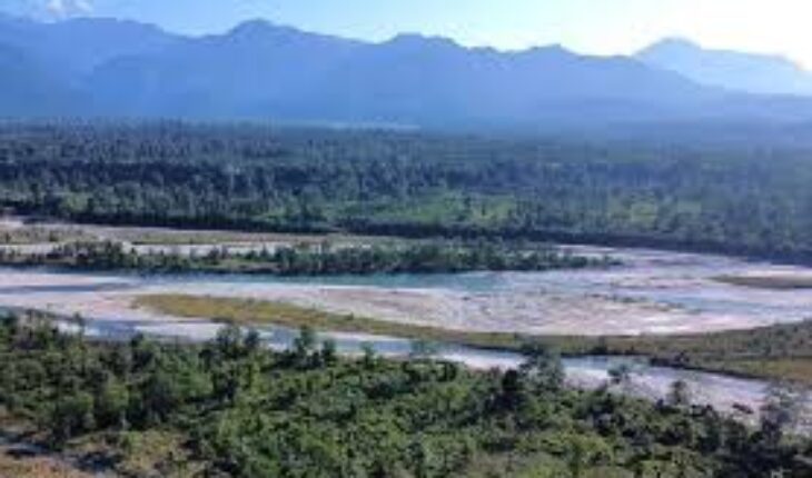
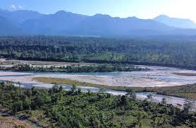
The road is part of the Southern East-West Highway (SEWH), a crucial transport corridor in Bhutan. It runs through Sarpang Dzongkhag, crossing the Gelephu Thromde and three Gewogs: Chhuzangang, Umling, and Tareythang.
The road’s alignment follows the lower-lying natural terrain of Sarpang and connects Gelephu’s airport, dry port, and multimodal transport hub, making it a vital link for trade and regional connectivity.
The road design includes two major components: 10.2 km of new greenfield highway construction and 3.4 km of road widening near Tareythang. The 3.8 km section near Gelephu will be a 4-lane dual carriageway, while the remaining 9.8 km will be a 2-lane single carriageway.
The expansion and construction efforts further aim to provide a smooth and efficient transport network, reducing travel time and increasing accessibility for local communities.
The 4-lane dual carriageway will have a total width of 18 meters, with each side measuring 7.5 meters, containing two lanes per direction. A 2-meter-wide central median, 0.5-meter-wide shoulders, and a 3.0-meter-wide cycleway or footpath will be included to improve pedestrian and cyclist safety. The right of way (ROW) for this section is 40 meters, and the design speed is set at 60 km/hr.
The 2-lane single carriageway will have a total width of 8.5 meters, with one 3.5-meter lane in each direction and 0.5-meter-wide shoulders. A cycleway or footpath will increase the total width to 11.5 meters, with a ROW of 30 meters and a design speed of 60 km/hr. This ensures that the road accommodates both motorized and non-motorized transport users.
A major highlight of the project is the construction of four major bridges along the route. These include the Mau River Bridge (1,005 meters), Jengkhurung and Taklai River Bridge (780 meters), Langer River Bridge (390 meters), and Singye River Bridge (382.5 meters).
The Mau River Bridge will have a 250-meter-long elephant corridor, ensuring a minimum vertical clearance of 5.8 meters to facilitate wildlife movement. This bridge will have two traffic lanes per direction and a pedestrian walkway.
The other bridges, ranging from 390 meters to 780 meters in length, will have one traffic lane per direction with pedestrian walkways. Their design considers wildlife conservation, with vertical clearance ranging from 5 to 15 meters. The project also includes river protection measures to prevent erosion and flooding.
At Mau River, protection works will cover 300 meters upstream and 100 meters downstream on the eastern side, and 500 meters upstream and 250 meters downstream on the western side. For the other rivers, protection measures will extend 400 meters upstream and 100 meters downstream.
The project will feature two major interchanges at Gelephu and Tareythang, enabling smooth integration with existing roads. These interchanges are designed to support future expansions in line with Gelephu Mindfulness City (GMC) and planned developments in Chhuzangang and Umling Gewogs.
The road will also include a minor bridge (80 meters) near the Gelephu Sewage Treatment Plant (STP) and several culverts for cross-drainage.
To support construction activities, the project will establish haul roads, quarry sites, crushing and batching plants, worker camps, and disposal areas. These facilities will be strategically located to minimize environmental impact and ensure the smooth execution of the project.
The project is expected to create significant economic benefits by improving access to markets, reducing transportation costs, and fostering regional trade. With better road infrastructure, businesses in the area will have enhanced connectivity to domestic and international trade hubs. Additionally, the road will provide better access to healthcare, education, and emergency services for local communities.
A key environmental consideration in the project is the biodiversity management plan. Given that the road passes through ecologically sensitive areas, measures have been taken to minimize disruptions to wildlife. The inclusion of wildlife corridors, such as the elephant corridor on the Mau River Bridge, demonstrates the project’s commitment to sustainable infrastructure development.
Furthermore, the resettlement action plan (RAP) has been developed to address potential impacts on local communities. The plan ensures that affected individuals receive fair compensation and relocation assistance, minimizing disruptions to their livelihoods. The social impact assessment also considers the needs of vulnerable groups, ensuring that the project benefits all sections of society.
The Gelephu-Tareythang Road Project aligns with Bhutan’s broader infrastructure goals, particularly in enhancing connectivity between southern and central Bhutan.
The project complements the government’s vision for economic diversification and regional development. By linking Gelephu to key trade routes, the road will play a crucial role in promoting sustainable economic growth.
The integration of climate-resilient infrastructure is another important feature of the project. The road design incorporates flood-resistant structures, ensuring durability against extreme weather conditions. This approach aligns with Bhutan’s commitment to climate adaptation and disaster risk reduction in infrastructure projects.
The implementation of the project will involve multiple stakeholders, including government agencies, local communities, and environmental organizations. Regular consultations have been held to ensure that the project meets the needs of all stakeholders while adhering to environmental and social safeguards.
With construction set to begin soon, the Gelephu-Tareythang Road is poised to become a vital transport corridor in Bhutan. The project’s impact will be far-reaching, providing a boost to trade, tourism, and regional integration.